Where we live
Oct 13 2014 · Graphics and Rendering
Using a number of technologies I’ve been playing around with recently, I began working on a 3D visualization of the Earth, plotting every city, creating a pointillism-styled representation of the planet. Below is the result along with an overview of how I produced the rendering.
Getting the data
I extracted all cities with a population of at least 100,000 people from the MySQL GeoNames database using the following query:
SELECT `id`,`name`,`latitude`,`longitude`,`population`,`timezone`
FROM geonames.cities
WHERE population >= 100000 AND feature_class = 'P';
… and put the results into a JS array.
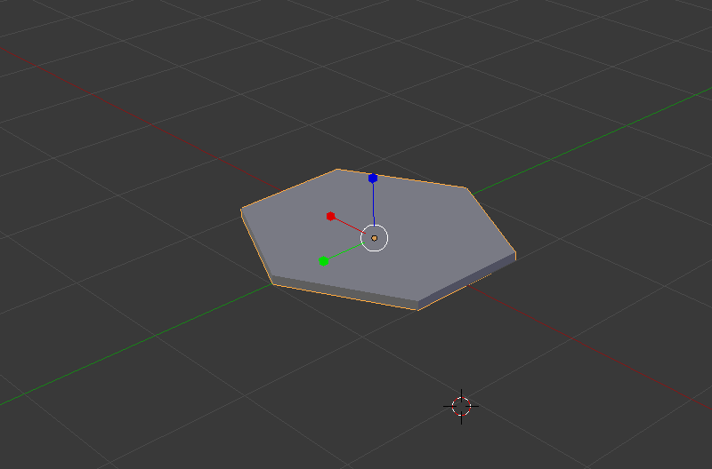
Creating a 3D model to represent each city
I created this hexagonal model in Blender, exported it to a Wavefront OBJ file, and ran the OBJ file through the Wavefront OBJ to JSON converter I wrote. Note that the model is facing the z-axis to match WebGL’s (and OpenGL’s) default camera orientation: facing down the negative z-axis.
Convert longitude and latitude to a 3D position
Converting a geodetic longitude, latitude pair to a 3D position involves doing a LLA (Longitude Latitude Altitude) to ECEF (Earth-Centered, Earth-Fixed) transformation. The code below implements this transform, converting the longitude and latitude of every city pulled from the GeoNames database into a 3D coordinate where we can render the hexagonal representation of the city.
function llarToWorld(lat, lon, alt, rad)
{
    lat = lat * (Math.PI/180.0);
    lon = lon * (Math.PI/180.0);

    var f  = 0;                                                     //flattening
    var ls = Math.atan( Math.pow((1.0 - f),2) * Math.tan(lat) );    // lambda

    var x = rad * Math.cos(ls) * Math.cos(lon) + alt * Math.cos(lat) * Math.cos(lon)
    var y = rad * Math.cos(ls) * Math.sin(lon) + alt * Math.cos(lat) * Math.sin(lon)
    var z = rad * Math.sin(ls) + alt * Math.sin(lat)

    return [x,z,-y];
}
There are 2 items worth noting:
- The transformation (and function above) involve a 4th parameter, radius which is the radius of the ellipsoid (or sphere, in this case, as flattening=0) into which the transformation is done. I have it set as a fixed constant, as I’m primary concerned with an approximate visual representation, but the MathWorks page describes the actual computation.
- The ECEF (Earth-Centered, Earth-Fixed) coordinate system has the z-axis pointing north, not the y-axis, so the z and y values need to be swapped to produce a coordinate corresponding to WebGL’s default camera orientation. In addition, as WebGL has a right-handed coordinate system (so the default camera orientation is one where it’s pointing down the negative z-axis), the z coordinate is negated so the point doesn’t wind up behind the camera.
Orient all cities to face the origin
Getting each of the hexagonal models to face the origin involved a bit of math:
- Calculating the axis about which the rotation should occur by, first, computing a vector from the origin to the 3D position of the model (lookAt), and taking the cross product between lookAt and the z-axis (as we’re rotating toward the z-axis).
- Calculating the angle of rotation (the angle between the z-axis and lookAt) by computing the dot product between lookAt and the z-axis, then taking the acos of the dot product.
There’s some additional code to handle cases where points lie on the on the z-axis (where the cross product gives the zero vector) and also to return a matrix representation of the rotation.
 function lookAtOrigin(v)
 {
     // compute vector from origin
     var lookAt = vec3.create([v[0], v[1], -v[2]]);
     vec3.normalize(lookAt);

     // reference axis
     var refAxis = vec3.create([0,0,-1]);

     // computate axis of rotation
     var rotAxis = vec3.create(lookAt);
     vec3.cross(rotAxis, refAxis);

     // compute angle of rotation
     var rotAngRad = Math.acos(vec3.dot(lookAt, refAxis));

     // special cases...
     if(rotAxis[0] == 0 && rotAxis[1] == 0 && rotAxis[2] == 0) {
         if(lookAt[2] > 0) {
             rotAxis = vec3.create([1,0,0]);
             rotAngRad = Math.PI;
         } else {
             rotAxis = vec3.create([1,0,0]);
             rotAngRad = 0;
         }
     }

     // compute and return a matrix with the rotation
     var ret = mat4.identity();
     mat4.rotate(ret, rotAngRad, rotAxis);

     return ret;
}
Render the scene
Using glfx, I pulled everything together, also adding a bit of code to rotate the camera and do some pseudo-lighting in the pixel shader by alpha blending colors based on depth. All the code can be found in the webgl-globe repository on bitbucket.


